The most useful mobile apps for an eight-month roadtrip across North America

There once was a time when the only help you had on a road trip was a map and maybe a guidebook and some local pamphlets. That is not today. Now with smart phones and an internet connection almost anywhere, there is a huge amount of information just a couple of taps away.

As usual, we used our phones to browse the web, check the weather, take photos and videos, and catch up on the news, but here are some of the other, more specialized apps that we found useful on the trip.

Navigation

On a road-trip, knowing how to get from A to B is the most important thing. Thanks to the generosity of Amalia’s former co-workers, we actually had a dedicated GPS device on our trip (a Garmin nüvi 2597), so once we knew where we were going, we programmed it in and didn’t have to worry about using our phones. But, if you don’t have a GPS device, a phone and mapping app of your choice will work just fine.

screen-shot-2016-10-18-at-11-16-53-am

Roadtrippers (iOS | Android): This was the website/application combo we used to map our trip before we left. You plug-in a place of interest, and Roadtrippers will add it to your route. Of course, depending on what other destinations you already have plugged in, Roadtrippers will find the best point in your journey to add the new destination and figure out the ideal route to see everything. You can have up to 60 destinations per trip (as of this writing), so if you’re planning a really long adventure like we did, you may need to build out four different trips.

Roadtrippers is also great because it will show you attractions and stops along your route, including accommodations, restaurants, roadside attractions, and that sort of thing. What we liked best, was that it showed scenic drives. If there was a scenic drive along the way that we could take instead of the interstate highway, we added it to Roadtrippers and it optimized the route. Totally worth it. Also, Roadtrippers can be used on your phone to provide turn-by-turn GPS navigation, but we didn’t use this feature.

screen-shot-2016-10-18-at-11-24-33-am

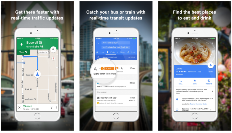
Google Maps (iOS | Android): A swiss-army knife of functionality, Google Maps was our go-to when trying to figure out where something was, and while walking around town. We starred local places we wanted to go (as opposed to Roadtrippers which was used to mark the major stops) and Google Maps told us the quickest way to get there. This was great for saving recommendations given earlier because once we arrived somewhere, we’d check to see if we had anything starred. Google Maps can also download maps of a limited size for offline use, but we would recommend either Pocket Earth (below) or Here Maps if you really want to limit your data usage. Of course, Google Maps can also be used as a turn-by-turn GPS and as a public transit guide.

screen-shot-2016-10-18-at-11-38-07-am

Pocket Earth (iOS): While it costs a few bucks, Pocket Earth allows you to download maps of entire states, provinces, or countries. We’ve used this app on our previous trips and it’s great for saving data. Unlike Google Maps, the limitations are based only on how much free space you have on your phone. Other benefits of Pocket Earth are that it will also download Wikipedia articles for any places you’ve downloaded as well at city guides for major cities. An indispensable resource for the traveller who wants to know more history about that weird looking cemetery across the road.

If you’re a hiker, Pocket Earth has another edge over Google Maps since it shows many of the trails present in national, state, or even regional parks. While it’s not as detailed as some of the dedicated trail apps you can download, we found it more than useful enough to figure out where we were on our hikes, whether there was an awesome viewpoint just around the next corner, or whether we should just turn around. For our purposes, we didn’t feel like we needed anything more complicated.

While Pocket Earth does kind of offer turn-by-turn navigation, it is pretty terrible compared to what you can get from the apps above, so we wouldn’t recommend it.

Places to stop

In addition to figuring out where we were and how to get around, we relied on a bunch of apps and websites to help us figure out where to stop when we needed gas, a place to stay, or just wanted to see something cool.

screen-shot-2016-10-18-at-11-38-52-am

GasBuddy  (iOS | Android): This app really does two things. First, it tells you where the nearest gas stations are, and second, it tells you which of those gas stations have the cheapest gas. While some might make a detour to save 50 cents, we quickly decided that wasn’t really worth it. We used GasBuddy to find the cheapest prices that didn’t require a detour, and figured out the best places to stop and get gas based on what prices were like where we were heading.

The cheapest gas we came across was in east Texas (40 cents a liter) and the most expensive was in Vancouver. Also, did you know that in Oregon it’s illegal to pump your own gas?

It’s also good to note that most GPS devices and apps will include a function to tell you about gas stations along your route, so if you’re not too concerned about price (which honestly isn’t gonna be a huge difference), you can just depend on those.

screen-shot-2016-10-18-at-11-39-34-am

RV Parky (iOS | Android): This app not only shows you the nearest campsites and RV parks, but it also shows nearby businesses that are RV-friendly, like Walmart. While there are other apps that might offer more details, photos, and the functionality to book sites, we found RV Parky to do just enough. With one look, we could see where the nearest legit campsites were and their approximate costs (which change depending on the season) or if there was a store parking lot somewhere that we could camp for free. While RV Parky has some reviews within the app, we would sometimes use Yelp (below) to supplement our research.

screen-shot-2016-10-18-at-11-45-56-am

freecampsites.net (appears to have gone offline): When you’re travelling on the cheap, you want to pay as little as possible. And while Walmarts are free, they’re not exactly scenic. Amazingly, in the American west there are many options for basic (no facilities other than an outhouse and sometimes not even that), free camping. We were really surprised at just how beautiful some of these spots were. FreeCamping.net is a website where people can add spots they know about. Some are on government land where camping is allowed, others are regional parks, and some are just sketchy fields. While we discovered lots of awesome spots this way, you can never be certain the site is gonna work out. Because of the nature of this website, some of the campsites have ceased to exist, or weren’t really free to begin with. If you’re in BC, then you should also checkout the provincial government’s directory of recreation sites, many of which have breathtakingly beautiful and free camping.

screen-shot-2016-10-18-at-11-52-24-am

Yelp (iOS | Android): Another really popular app, we used Yelp to figure out where to eat (fun fact: vegan food is everywhere!), get coffee, check out a local bookstore, or whether a potential destination was really worth going to. The other popular app in this category is Trip Advisor. Really, you can’t go wrong with either.

screen-shot-2016-10-18-at-11-54-45-am

Atlas Obscura: Looking for something strange and off the beaten track? Atlas Obscura is a website directory of the strange and wonderful. We weren’t gonna go out of our way to see the graveyard of old Ford trucks in Florida, but since it was on the way, we’re glad we knew about it and were prepared to pull over to stop.

screen-shot-2016-10-18-at-11-56-39-am

Chimani National Parks (iOS | Android): There doesn’t seem to be an official National Parks app for the US, but there are several third-party ones that do a pretty good job. Chimani’s was the most useful, easy-to-use, and elegant experience we could find. It showed a map of the US with all the parks and historic sites, so it was easy to see where they were located and which were near us. It also provided a brief description of each park and the ability to mark which ones you’d visited (55!!). While Chimani also provides separate, more detailed apps for the some of the bigger American parks, we regret to say we kept of forgetting to try them.

Recreation Equipment Inc (REI), a US coop the equivalent of Mountain Equipment Co-op (MEC), also has a national parks app, however it only has a handful of the hundreds that exist. What it does provide, are some pretty great maps.

There is no national parks apps for Canada. Well, okay, there are two you can download, but they are both useless pieces of junk that neither provide a list of parks, or any other relevant information to the road adventurer. Even the government website sucks, as there’s no way to see the parks on a map. We picked up a paper map when we bought our Canadian parks pass, but even though it was only printed last year, we kept on passing parks that weren’t on it. Get your shit together Parks Canada.

Social Media: Often, most of the places we hear about are from people we know both on and offline, so social media posts about others peoples’ adventures on Facebook and Instagram were a huge inspiration for us (hello #ladiesmountaineeringclub on Instagram). We could search for the names of places we were going and see what other people enjoyed most.

Internet browsing

Of course, using alls these apps requires internet, and while Starbucks was our best friend for really fast free internet in lots of places (we plugged a “Starbucks” search into our car GPS so we always knew where the next one was), we still had to stop at sketchy internet cafes, and dip into our mobile data regularly. A long the way, we found some really useful apps for helping with that.

screen-shot-2016-10-18-at-11-57-21-am

My Data Manager (iOS | Android): Unlike Canada, mobile plans in the US are way more generous. The cheapest plan we could get included 5GB of high-speed LTE data, and unlimited low-speed data. But, let me tell you, that low speed data sucks when its 7 pm and you can’t find the campsite and you’re trying to load on Google Maps. So, we needed a way to track our data usage more intelligently. That’s where My Data Manager comes in. Not only does it keep you up-to-date with where you’re at with your monthly data quota, but it breaks things down so you can see how much data you should be using on a daily basis to ensure you don’t run out. That number is updated based on your usage, so if you have a 200mb quota for Tuesday and only use half, My Data Manager will recalibrate the next day to take that into account. It was great for the trip, and Ben is still using it now.

screen-shot-2016-10-18-at-11-58-08-am

Roam Blocker (iOS): This is a Safari extension for iOS, but there are likely equivalent extensions for Android. Roam Blocker is a bit like an add blocker, but instead of blocking ads, it blocks images. If you’re doing some surfing sans-wifi and don’t need images, enabling this extension will dramatically cut down on your data usage.

screen-shot-2016-10-18-at-11-58-33-am

TorGuard (iOS | Android): Sometimes you’re in a sketchy bar or cafe which has wifi but you don’t really trust the network (tip: never trust the network, even at Starbucks).In these scenarios, having a Virtual Private Network (VPN) like TorGuard is nice. Essentially, what TorGuard (and the hundreds of other services like it) does is encrypt your internet traffic and channel it through their servers, making it much more difficult for people in that sketchy bar or cafe to intercept your internet traffic (and passwords). TorGuard is the one we used, but again, there are lots, though some work better than others.

Banking

When you’re travelling, you have to pay for things, and it’s important to be able to keep track of what you’re buying, and to be able to move money around between accounts when necessary. To make this easy when you don’t want to haul out your laptop, you’ll need your bank’s official app, many of which now more easily allow you to track purchases, but if you really want the best way to track your purchases and monitor your budgets, you want …

screen-shot-2016-10-18-at-11-58-56-am

Mint (iOS | Android): This is a website and app that connects to all your bank accounts. It then just watches for transactions, guesses at what they’re for (Starbucks = coffee, AT&T = mobile phone, Husky = gas), and files them under the appropriate budget. It makes it easy to see how you’ve been spending your money and track where you are in terms of your monthly budget. It will also send you warning messages if you approach or go over your budget, or make any unusually large purchases. Mint doesn’t do anything else like allow you to pay bills, it’s just an indispensable way to track your spending (and earning).

Entertainment

No road-trip is complete without some great listening material. While we considered audio books, we could never agree on what to “read” so podcasts and music were a huge part of the adventure. Most phones come with built-in music and podcast players, but make sure the things you’re listening to are actually stored on your phone. Those streaming music services might have huge libraries of music, but that will eat through your data plan like cookie monster devours chocolate chip cookies. Our podcast player of choice: Overcast (iOS).

screen-shot-2016-10-18-at-11-59-29-am

Our trip by the numbers (nerd alert)

As much as we planned for our trip, we really didn’t know what to expect. We’d charted a route, but didn’t know if we could stick to it. We’d made up a budget, but it wasn’t based on much more than guess-work. We had an old minivan, but didn’t know if it would make it or turn into a money-pit of repair work.

Fortunately, things mostly worked out. One of our biggest surprises was that there was more driving than we had anticipated. You can plot the route from destination a to destination b but there’s always a bunch more driving in between, whether it’s back and forth from the campsite or just around town. In addition to that, we ended up going to substantially more places than we planned (at least until Dodgy got that poor bill of health in Edmonton).

Our initial driving estimate was about 30,000 km over the course of the trip, and the final distance was 39,790 km. If we had had our wish and taken the adventurous route back from Edmonton, it probably would have been closer to 45,000 km.

Here’s the map of the planned route:

route1

And here’s the map of the route we actually took:

route

All in all, we were on the road for a total of 226 days. Of that, we spent over 568 hours or almost 24 days driving. Our average speed? 70 km/h. Our top speed? 138 km/h (welcome to driving in Texas).

We saw 26 states, 5 provinces, and 1 territory. We visited 55 national parks/historic sites in the US and 10 national parks/historic sites in Canada.

Where did we sleep? With the full-size mattress in the back of the van, we were pretty flexible, but we camped a lot and spent almost as much time staying with family and friends.

screen-shot-2016-09-19-at-1-47-07-pm

Given how much we spent on camping (see below), the average amount we spent camping was only $17.10 per night. Not bad.

So, the initial budget for the 10-month trip was about $31,000. We came back after only 8 months and spent about $25,000 which pro-rating the original budget is pretty much right on the money.

Expenditures were tracked pretty accurately by Intuit’s online expense-tracking service Mint, with the following two caveats. First, we didn’t bother to track expenses paid in cash which probably added up to a couple of thousand of dollars (included in the estimate above). Given the outlook for the Canadian dollar at the beginning of the trip, we brought most of this cash with us and used it strategically. We also always made sure to have some cash on-hand for those places that accept nothing else.

screen-shot-2016-09-19-at-1-47-23-pm

The largest expenditure were food-related, which we assumed would be the case. Restaurants are expensive even though they made up a minority of our meals. We could have saved by eating out even less, but then we’d have missed so many amazing flavours and fantastic regional dishes. Alcohol was also included as a food expenditure in the initial budget, and when you lump those three together, we hit the budget right on the money. Experiencing local beer, cider, and food is a big part of travelling for us. Not many regrets here.

We hadn’t budgeted quite so much for auto service and parts, but getting the brakes rebuilt in Whitehorse was not cheap ($900) and then we had to get the outer tie-rods replaced in Edmonton ($400).

Gas ended up being more than budgeted, but that can easily be chalked up to the extra driving we did.

We spent far far less on accommodation than we predicted. But, once we got used to Walmart parking lots, guerrilla parking on the street, and finding free campsites, our costs really went down. It also helped that we spent so much time staying with family and friends. Thank you ❤

Mobile phone expenses were high only because Ben had to buy a new phone on the trip (~$750). We almost didn’t include it in the budget, but it’s the type of expense that happens.

All things considered, we attempted to be as frugal as possible, to reuse what we had, to avoid waste, and to reduce our consumption. Purchasing a national parks pass for both the US and Canada gave us extremely affordable access to breathtaking environments. We refused to go to many privately-run museums and attractions as a way to save money, especially if the cost was over $10.

Looking back on the trip, we made some good (cheap) decisions that allowed us to continue on our journey while also having an amazing time.

All the hits: week thirty-four (in which the van fails a medical exam and we cut our trip short)

While in Edmonton we took Dodgy (our van) in for some regularly scheduled maintenance (oil change, tire rotation – that sort of thing). The mechanic was not impressed with the state of the van … he may have used the term “death trap”. After taking Dodgy in for a second opinion we were convinced that, with a little bit of work, we could safely drive back home, but that it would be foolish to try to take the meandering, off-the-beaten track route that we had initially planned.

So, from Edmonton we charted a new course – one that followed the shortest route distance-wise to Kitchener, Ontario. Despite the accelerated return, we still managed to see some cool stuff along the way.

The Original Nosh (in Saskatoon, Saskatchewan): We needed to find somewhere for dinner and this vegan-friendly restaurant on the south-side of the river seemed to fit the bill. We had the Buffalo Cauliflower Tacos and No-So Po’ Boy wth cornmeal-crusted fried oyster mushrooms and cashew cheese. Damn, it was good food. Also, we had some local beer. A satisfying way to end a long day of driving.

Here’s The Thing with Alec Baldwin: An ongoing interview series on WNYC public radio and available by podcast, we discovered this on our drive back and basically binge-listened to it the entire way.

Prairies and lakes: Some people complain about the “long boring drive” across the prairies. Those people don’t know what they’re talking about. Maybe it’s because we were on Highway 16, but the gold fields, green groves, and cobalt blue lakes never ceased to impress us with a sense of timeless beauty. We also learned that the Quill lakes in Saskatchewan don’t drain into any rivers, instead they evaporate and are up to three times as salty as the ocean. Who new?!

Riding Mountain National Park (in Manitoba): We stopped here because it was on the way to Winnipeg, but it failed to impress. If we had more time and a vehicle we trusted on dirt roads we might have explored more, but, once again, we found ourselves frustrated that the Park didn’t seem to provide any recommendations for quick day-hikes, only information about the shopping district and the golf course.

Stella’s Café (in Winnipeg, Manitoba): Upon arriving in Winnipeg we were ready for some lunch/brunch. Any place with scrambled tofu is a worthy brunch place in Ben’s books, so we headed to Stella’s. There are actually several as it’s a local chain, but ours had a patio so that was another win.

We had a great time in Winnipeg, partly because we were able to crash with some awesome friends who had a house with a great yard, garden, and great ideas about fun things to do (thanks Liz and Robin! <3). Together, we made delicious pizza, kale chips, and pie. We were also introduced to the game of Munchkin. Lots of fun!

The Forks: Winnipeg is built around the intersection of the Assiniboine and Red rivers. This part of the city is known as The Forks and is a National Historic Site. After grabbing lunch in the market, we spent much of the afternoon just lounging in some muskoka chairs and enjoying the weather.

Thunder and lightening and mosquitoes: Never had either of us seen lightening storms like we did in Winnipeg. The storms were spectacular and seemed to go on for hours. We tried to catch the impressive display on video, but couldn’t do it justice. The mosquito attacks were also unlike any we had experienced before. They were everywhere, and even in the heat of the day they were out and biting.

Boon Burger (in Winnipeg): So there’s this amazing vegan burger joint in Winnipeg called Boon Burger. Our friend Barry took us there (meeting friends along the road has definitely been one of our favourite things) and we ate some absolutely epic and very tasty burgers. Too bad they don’t deliver out of province.

Across the Board Game Café (in Winnipeg): Ben had been to a board game café once before and Amalia had never had the experience, so we were both excited when the opportunity presented itself. Ben finally figured out how scoring in Carcassonne works, a game of Blokus was played (but not eaten even though the pieces look like Jolly Ranchers), and we finished off the night by discovering the great fun that is Las Vegas the game (definitely better than the real thing). Then home through the rain and thunder of another lightening storm.

Delicious Vegetarian (in Winnipeg): Really, the name says everything, but on our way out of town we stopped at this delicious vegan Chinese restaurant for lunch. The food was really good.

After Winnipeg, we crossed back into the US and made our way to Duluth, Minnesota where Amalia’s aunt, uncle, and cousins live. Staying with Amalia’s aunt and uncle, we were treated to a lovely room above the boathouse looking out over a small lake. It was pretty amazing. While there, we were treated to great homemade food, local (and imported from Canada) beer, boat tours of the lake, and great conversations.

Gooseberry Falls State Park (in Minnesota): It was Amalia’s cousin’s daughter’s 13th birthday, and she was eager to see some water falls. So we headed up the north shore of Lake Superior to Gooseberry Falls. It was pouring rain, but we had a lot of fun scrambling over the rocks and exploring the many tiers of the falls. Definitely a fun place.

Hawk Ridge and Enger Tower (in Duluth, Minnesota): The next day we drove out to Hawk Ridge, an escarpment that offers spectacular views of parts of Duluth and Lake Superior. Standing on the ridge, which gets its name from the thousands of hawks that migrate through the area every year, we could see for miles and miles and miles. Further south, Enger Tower is a stone tower built on the hill-side which offers more panoramic views of the city and port-lands. Beneath us we caught a glimpse of the giant sailboats in dock as part of the tall-ships festival – as well as the giant rubber ducky that seemed ready to push them down into the depths of Lake Superior.

Rice Paddy (in Marquette, Michigan): After another long day of driving we found ourselves in Marquette and really hungry. It was late, but looking online we saw we could grab some Thai takeout from Rice Paddy before it closed. The reviews were good and the food was super-cheap so we were really curious about what we were gonna get. The answer: a couple of huge portions of scrumptious pad thai. Yum! We spent the night chowing down while watching an incredibly loud and windy lightening storm swirl around us in the Walmart parking lot.

Pictured Rocks National Lakeshore (in Michigan): Another national park that happened to be on our route back, it was nice to be able to stop and stretch our legs. The park was established to celebrate and protect the 200-foot tall sandstone cliffs along this stretch of Lake Superior’s south shore. There are a lot of really cool waterfalls and rock formations to see here, but we had to limit ourselves and keep moving on.

The Mackinac Bridge (in Michigan): It’s a really beautiful bridge with stunning views. We originally wanted to go the Mackinac Island, but we’ll have to save that for another trip.

Greens Organic Cafe and Market (in Sarnia, Ontario): Initially, we wanted to stop at the ThumbCoast Brewing Company, where we had our first beer of the trip. But, our desire to get the boarder crossing over with won out, and so we stopped for lunch in Sarnia instead. Green was delicious and fresh. The Kale soup was particularly good.

And so, with this post, the last leg of our trip was completed. We made it to Kitchener, Ontario in the mid-afternoon and began the process of unpacking the van and figuring out what we should do next.

This isn’t the last blog post though. We have a few more coming with some top-ten lists and other interesting facts about our trip.

All the hits: weeks thirty-two and thirty-three (in which we explore Alberta’s mountains and mountain houses)

Jasper National Park

The entrance to Jasper follows a river into the towering Rocky Mountains. We’d already seen a lot of mountains on the trip, but they hadn’t lost their majesty. Unfortunately, no information was provided to us at the gate so we had to drive an hour through the park, passing many trail heads, and into town to find out what we should do. It’s unfortunate, because we had passed a few things on our way in that we didn’t know about and, given our schedule, we weren’t going to add another two hours of driving just to go back and see them.

Maligne Canyon: Our first major stop in the park was this spectacular canyon. Several trails trace the canyon’s route as it carves its way through the mountain rock. Starting as a small river carving it’s way down out of the mountains, other streams of water squeeze their way through the porous rock on either side of the canyon and the river gradually becomes a raging torrent by the time it exits the canyons walls. The park was busy, but the hike was very enjoyable and it’s always nice when there’s a coffee shop at the half-way point.

Mt. Edith Cavell and Glacier: Edith Cavell Mountain is remarkable and instantly recognizable. Again, since the park can be so busy with tourists, we got up early and made sure to get to the trailhead before the crowds. After a curving drive up the mountainside, we found ourselves staring up at the towering sheer face of the mountain. From the parking lot, a short trail leads up to the base of the mountain and gave us a view of a large hanging glacier with a gushing waterfall emptying into a lake below. It was fantastic, although, due to global warming, the glacier is only a shadow of its former self. While making our way along the path, Amalia discovered the hard way, along with dozens to follow, that a group of wasps had set up a nest just off the path. We let the park rangers know.

Water and ice: The Icefields Parkway runs south from Jasper down to Banff, and is bordered by towering mountains on both sides. It is a spectacular drive with many things to see along the way including both Athabasca and Sunwapta Falls (though Maligne Canyon was more interesting). The main feature at the south end of Jasper National Park is the Columbia Icefield and the Icefields Centre. This icefield is the largest in the Rocky Mountains and is composed of a staggering 325 square kilometres of glacier. Unfortunately, the Centre was so busy that there was no where to park. We did drive up to the base of another glacier though and were very impressed with it’s massive scale.

Banff National Park

Banff is located directly south of Jasper and after the Icefields Centre, we crossed from one park into the other and continued the beautiful drive to Lake Louise.

Moraine Lake: While many drive up to Lake Louise, we took route slightly less traveled by continuing half an hour south to stop at Moraine Lake. Both lakes are really quite beautiful. The colour of the water is unbelievable and the glaciers and mountains that frame the lakes are just fantastic. Moraine Lake seemed more dramatic as it is located in the Valley of the Ten Peaks. We hiked a beautiful trail though the woods on the edge of the lake, with dozens of beautiful glimpses of the lake bordered by the trees. At the end of the trail, the roar of a glacier river rushes into the lake beneath the forest canopy. There were a pair of ducks diving for food so Amalia put her foot into the water and retreated immediately. Glacier fed lakes are absolutely freezing.

Bow Valley Parkway: The next morning we got off the main highway and took the more scenic Bow Valley Parkway to Banff. It was a beautiful drive with a certain section where the two lanes of the highway divided and we found ourselves driving through the woods on a single lane of pavement. The isolation gave us the opportunity to observe a doe and her two small adorable fawns grazing on the side of the road.

Cave and Basin National Historic Site: Located within Banff, this site marks the beginning of Canada’s national parks system in 1885. A hot spring pool located in a cave, the site has been home to Indigenous ceremonies for thousands of years. Unfortunately, once it became a tourist destination (something that happened before it was part of a national preserve), much damage was done to the spring and its surroundings. Only recently has a reconciliation project taken place and Indigenous peoples are once again able to hold ceremonies at the site. The springs are also home to a unique species of snail and so for that reason, humans are no longer allowed to bathe in them.

Rocky Mountain House and Edmonton

Rocky Mountain House: Having exited from the mountains, we made our way back north to Edmonton along the Cowboy Trail scenic highway and stopped at Rocky Mountain House. Unfortunately, we got there rather late and so were rushed for time (rain clouds were also moving in with threat). But, we were able to explore the museum on site and take a walk along the site’s outdoor trails. Located on a river, this is formerly the site of several fur and supply trading posts setup in the eighteenth century. There were several historic actors setup on the site’s grounds, although they were mostly packing up their wares when we got there. Still, it was a fascinating glimpse into life on the “frontier” in the early 1800s.

Padmanadi Vegetarian Restaurant: We got into Edmonton in time for dinner and found ourselves both a little hangry. Blocks from the place we were staying (thanks Robin!) was a vegan Indonesian restaurant so we thought we’d give it a go. First of all, we hadn’t been to a “vegetarian” restaurant since Vancouver, so we were pretty excited. Second of all, holy crap this place was good. We stuffed our faces with delicious food and the standout was definitely the vegan prawns with lemon sauce. Oh, and we went back again before we left town.

Bonus: Veggie Garden (another good vegetarian restaurant, but not the same calibre as Padmanadi), Beer Revolution (lots of great beer and food even if it’s in a big box strip mall).

All the hits: week twenty-eight and twenty-nine (in which Ben realizes he has lost track of the weeks – five to be specific)

Whitehorse, Yukon

We had been looking forward to visiting the Yukon for much of the trip, and Whitehorse was our home-base for almost two weeks while we explored. The entire territory is only 37,000 people (27,000 of whom live in the immediate Whitehorse area) but luckily a few of them were old friends who showed us some of the awesome things the territory has to offer.

The Light: Visiting in mid-July we got to experience some pretty long days. The sun didn’t set until 11pm and it wasn’t dark until well after midnight. While we knew it was gonna be weird, but the fact that the evening light still starts at around the same time triggered a certainty that the sun would soon set … that was never the case.

Local craft beer: We enjoyed a lot of Yukon beer while visiting, mostly from the Yukon Brewing Company. As part of our orientation, we were told that the Yukon might be the only province/territory in Canada where a majority of the beer purchased is craft beer. It’s easy to believe. The Yukon Brewing Company is an institution. We enjoyed some tastings at both breweries and had no shortage of beer to drink while we visited.

Making lasagna: Okay, so not a Yukon-specific experience, but it was here that we made lasagna for the first time ever. It was awesome fun. While it’s not a road-trip friendly dish, we’ll be making a lot more when we get back to having access to an oven.

Yukon Wildlife Preserve: This is the home to a variety of rescued creatures from across the territory. Given some fairly large spaces to roam, we were able to spend some time watching (sometimes through binoculars) some elk with giant antlers, a couple of caribou who wandered into view, deer, bison, thin-horned sheep, mountain goats, muskox, a lazy lynx, some very active arctic foxes, and some cute, but not as cute as they are in winter, snowshoe hares. We were also constantly being spied upon and circled around by the local arctic ground squirrels who chased each other around and popped up onto their hind legs to chirp at us. While we couldn’t find the moose in their large domain, we were treated to up-close encounters with a bald eagle and peregrine falcon, both of whom were (hopefully) temporary residents at the Preserve.

Bean North Coffee Roasting Company: Located beside the reserve, this tranquil coffee shop in the middle of the country made some great coffee and snacks. It was really lovely to be able to sit on the big patio and enjoy one of the few days of nice whether we had in the north (it was unseasonably rainy while we were there).

The Whitehorse community: The community of Whitehorse is really quite lovely. It has a unique small-town quality in that it is a small-town, but it isn’t really defined by any larger nearby cities (because there are none). We met lots of really friendly locals.

Bonus: S.S. Klondike (an old steamwheeler that used to move supplies down and gold up the Yukon River), Well-Read Books (the great used bookstore in town), more disc golfing (this time with beer and a dog), the Mud Bog (souped up trucks racing through mud troughts), Midnight sun coffee (another great coffee place in town).

Carcross and Atlin

Dodgy (the minivan we’ve been driving around the continent in) had some brake trouble while we were in town. We thought we might be stuck in Whitehorse for the week, despite our desire to go exploring. Luckily, our friend Élaine was awesome and lent us her car so we could drive to Carcross and Atlin.

The Carcross Desert: Just south of Whitehorse is Carcross. After driving between mountains and around lakes, as we descended into Carcross we suddenly found ourselves surrounded by large sand dunes. Called the smallest desert in the world, the climate is actually too humid to qualify as a desert. The dunes here were formed by silt left be receding glaciers. The town is also pretty cute, with some touristy shops and a lot of history.

Atlin: Atlin is a very small town on the largest natural lake in British Columbia, but you can only get there by first driving to the Yukon and then (almost) to Whitehorse. The views along the drive, and from town, are stunning. Across the lake, glacier peaked mountains are easily visible and there are beautiful views in every direction. We camped at a free site south of town near some hot springs, but due to lots of rain we couldn’t get great photos and also didn’t take advantage of the springs (silly). We almost got stuck there. On our way back into town on a dirt road, we came around a corner and found a tree had blow over in the night and blocked the road. We spent about two seconds seeing if we could drag it out of the way, but it was a big tree and it wasn’t going anywhere. So we very carefully drove over/around it.

The Northern-ish Yukon

The Dempster Highway: Once Dodgy was ready to roll again, we headed north, yes, further north. The highway to Dawson is a pretty standard highway. As with many roads in the north, there are stretches of gravel here and there but the views are beautiful. But our first stop wasn’t Dawson, it was Tombstone Territorial Park. To get there, you have to take the Dempster Highway which starts just east of Dawson. It’s called a highway, and the speed limit is 90 km/h, but don’t fool yourself, it’s a dirt road with lots of pot-holes. With all the rain, it was a very muddy drive. Tombstone is about an hour’s drive north on the highway, and when we got there, it was like the entire back half of the van had been painted brown. More adventurous travellers were taking the highway up to Inuvik (Northwest Territory) and to the Arctic Circle, but there’s no way we were gonna try that trip without a high-clearance, oversized tired, all-wheel truck. Just, no.

Tombstone Territorial Park: Tombstone is where we got a taste of the arctic tundra and Biringia. The tundra is the ecosystem where the soil is so thin and perpetually frozen so only small plants can survive. Biringia is an area that encompasses parts of the Yukon, Alaska, and Siberia where there were no glaciers during the last ice-age. It’s the land-mass that formed the land-bridge that humans used to cross into the Americas thousands and thousands of years ago. Combine the two and it’s a pretty unique ecosystem. While is was cloudy and rainy most of the time we were there, we took some awesome hikes, ate some berries (we were told all the berries in the park are edible), spotted a grand variety of mushrooms, and Amalia  picked some delicious Labrador Tea from the tundra. We also really enjoyed the campground lodge at Tombstone. Common to many Yukon Territorial campgrounds, but in full effect at Tombstone, the lodge is an enclosed space with four picnic tables and a big roaring wood-burning stove in the middle. There’s something special about returning from a long damp hike to relax around the stove with other travellers. There were also about a hundred wolf spiders in jars stacked in the corner (scientific research), but Ben did his best to ignore them.

Dawson City: A gold rush city, Dawson is located north of Whitehorse, but down-river from Whitehorse. So one drives *down* to Dawson. With so much history, the city itself is a National Historic complex, with many gold-rush era buildings and museums. Due to its status, even new buildings have to be designed to look as if they were built in the 1890’s. Needless to say, the town is picturesque and has a lot of character. With so much to see, we decided to take a town tour that contrasts what it’s like to live in the town in the present day with what it would have been like to live in the town during it’s golden era. Because of our schedule, we couldn’t spend too long in Dawson, but there is a lot more we would have loved to do and see. Several days in town are definitely recommended and we hope to come back here someday.

The Alaska Highway and Northern British Columbia

Wildlife along the Alaska Highway: The drive south from Whitehorse to Alberta was another beautiful trip. And, even though it is a much busier road than the Casiar-Stewart highway, we saw a lot more wildlife along the way. Highlights included bison (hanging out either alone or in large groups), black bears munching away on the greenery, curious woodland caribou, distant mountain goats, foxes, gray jays, and giant dragonflies.

Liard Hot Springs Provincial Park: We had a shortlist of things to stop and do on our way down, and the Liard Hot Springs had been mentioned by multiple people. Nestled in a lush green canyonesque valley, a fifteen-minute walk along a boardwalk through the marsh and forest brings you to the springs. Developed for human bathing, the springs empty into a two-tiered pool to allow for different temperatures. The top pool near the spring was super-hot (almost 40 degrees celsius), but the lower pool was just the right temperature to unwind from so much driving. Surrounded by the trees, it was a beautiful setting to relax – Ben didn’t really want to leave. Walking further up the hillside, there is a slope teaming with interesting ledges and plant-life as another spring outlet trickles out of more cracks and creates a hanging garden. The only off-putting aspect of the stop were the pit-toilets. At no point on our trip had we come across so many toilet-dwelling flies. Like something out of a movie, when opening the toilet lid, a thick, spiralling swarm of flies came rocketing out of the blackness below. Ew. To the bushes Amalia went.

Mountain Lakes: There were so many beautiful mountains, rivers, and lakes along the drive. It is a special feeling to come around the shoulder of a mountain, and see a valley before you, filled with glistening, bright blue water. Muncho and Summit lakes were especially stunning. We camped at Summit lake where a lovely trail loops up into the mountains, passing through forest, meadow, and tundra.

Baked goods: There isn’t a lot between the communities of Watson Lake and Fort Nelson, but there are a few treats to be had along the way. We had some amazing home-made bread and a succulent cinnamon bun in Toad River.

All the hits: weeks twenty-five, twenty-six, and twenty-seven (Yukon Bound!)

Salt Spring Island

We had planned to spend the Canada Day long weekend in Vancouver to visit a few friends, but all of them were going to be out of town. Luckily, three were going camping together and invited us along. The site for the weekend’s festivities was Ruckle Provincial Park on Salt Spring Island. While we weren’t heading to the mainland yet, we were finally saying goodbye to Vancouver Island after almost a month.

Salt Spring is one of the most popular and populated islands between Vancouver Island and the mainland, but the Park where we were camping was on the very tip and fairly isolated. To get to the campsites, you have to park and then use one of the wheelbarrows supplied by the Park to walk your equipment into a site. While we were used to backpacking stuff in, the barrows helped make the process that much easier (especially since Amalia’s foot was still on the mend).

When we arrived on Wednesday the Park was already pretty full but we were able to grab a couple of sites right on the ocean. The views from the site were amazing as we could look out onto the ocean and see many other islands (including the Washington ones). We were also right on the main ferry path from Tsawwassen (near Vancouver) to Swartz Bay (near Victoria). While we were a little apprehensive at first, watching the giant ships cruise by (especially at night where they were lit up like chandeliers) proved to be a highlight of the weekend.

We spent several wonderful days on Salt Spring. The weather was amazing, we got to work on our tans, the group of friends was great fun (there were 10 of us in all), and we had a very relaxing time.

Vancouver

After the long weekend we headed to Vancouver for a few days. Although we were staying out in New Westminster (thanks Mike and Kate!), we had easy access to downtown via the SkyTrain.

We spent a bit of time and had lunch in Stanley Park with Ben’s cousins Cameron and Heather (and baby Brianna who seemed skeptical of Ben’s beard). At the recommendation of several people, we visited the Museum of Anthropology at the University of British Columbia where we admired the many Indigenous artifacts and artwork, especially the special exhibit “Unceded Territories” by artist Lawrence Paul Yuxweluptun. His work was bright, colourful, and politically provocative (in the good way).

We had many delicious meals in the city including vegetarian Dim Sum at Po Kong, mind-blowing vegan chicken wings and other delicious food at Meet on Main, an unbelievably filling breakfast at Bandidas Taqueria (must go back), a little bit of Cypriot flavour at Takis’ Taverna (Amalia’s dad’s name), and then a magical sunset beach BBQ (thanks Ian and Victoria!).

Bonus: Minit-Tune & Brake Auto Centre (for happily reassuring us that the liquid we found dripping from the van’s engine was just condensation and for not charging us for the diagnosis), the mushroom gravy at the Stanley’s Bar & Grill (amazing), the beer at 33 Acres Brewery, drinks with friends at The Black Frog, Aperture Coffee, Turks Coffee, Baaad Anna’s knitting store.

Northern British Columbia

After our time in Vancouver, it was time to head North. Our next destination was Whitehorse in the Yukon, but the drive is a long one from Vancouver – 28 hours. Instead of pushing ourselves too hard, we decided to take our time and do the trip in 8 days.

We past Bridal Veil Falls on the way out of town (Ben remembers them from when he was a kid), but while we appreciated them from a distance, Amalia’s foot was still sore and she was only up for one hike that day which is why we stopped instead at Coquihalla Canyon Provincial Park to see the Othello Tunnels. The former site of a railway through the mountains, a series of tunnels and trestles now form a short but impressive hike through a canyon. It was very cool.

From Coquihalla Canyon we headed north to Lillooet following the Fraser River. The final part of the drive on the Lytton-Lillooet Highway (12) was quite an adventure. A lot of the highway runs alongside a fairly deep drop-off and their are winding stretches that are gravel and just a single lane (where you can’t really see if someone is coming in the other direction … luckily no one was). A hilarious sign on the way in and out of Lillooet stated the following wise words: “If at first you don’t succeed, skydiving isn’t for you” and “Small town ahead, don’t believe anything you hear”. That night we stopped at the Seton Lake Campground which is provided for free by BC Hydro.

The next day we stopped at Horstings Farmers Market for supplies, Chasm Provincial Park for a pretty cool view of a canyon carved by a glacial river 10,000 years ago (thanks for the recommendations Tracy and Bobby), and then continued north to an beautiful free campsite on Chubb Lake. British Columbia has a whole network of primitive, free campsites, with extremely clean pit toilets, and we planned to take full advantage. Every day of our drive it rained for at least part of the day, and on this evening we were treated to a major thunderstorm – in the distance, and then up close. Up until this point, our encounters with mosquitos had been few and far between. Unfortunately for Amalia (who they love), that was about to change. During most of our camp-outs between Chubb Lake and Whitehorse we had lots of little hungry friends in the form of mosquitos and black flies that were eager to say hello. Within hours Amalia was swollen and itchy in many places. Ben was annoyingly less appetizing.

On Saturday we got up in the pouring rain and headed to Prince George for coffee. As it turned out, that weekend was Pride weekend in Prince George, so we got to see the Prince George Pride March which was pretty great and happened to occur while it wasn’t raining. As we headed out of town we found ourselves driving through a torrential downpour of carwash intensity – definitely the hardest it had rained since Florida. As we continued on, we passed lake after beautiful lake, gorgeous green forests, happy deer, and cuddly black bears. We spent the evening at another beautiful free campsite on Kager Lake. We drank wine and read on the dock while watching a pair of beavers collect wood for their house.

It was pouring rain again the next morning as we headed west (the route to the Yukon is anything but direct). The day saw us enter some pretty awesome mountains and leave the main highway that connects Prince George to Prince Rupert. Taking Highway 37 north, signs of civilization (and mobile reception) disappeared. We were really in the middle of nowhere. We drove further into the coastal mountains as we took a detour towards a small town called Stewart. The stop had been recommended to us by our friend Laura and wow, was it ever spectacular. The drive itself was worth the trip as we navigated down a winding mountain canyon towards Stewart (which is at the head of the 114 km long fjord). The highway provided lots of wildlife spotting as well as the sudden appearance of Bear Glacier emptying into a road-side lake. It was the first glacier Amalia had ever seen, and as we looked around we realized we were surrounded by them. Everywhere we could see their presence, either as caps of ice majestically settled into mountain valleys, or the hundreds of waterfalls cascading down from all sides. We spent the night at yet another free campsite on Clements Lake with the sound of a glacial waterfall thundering in the distance

We woke up to a cloudy morning and headed into Stewart. The town is quite quaint and is home to an international port where large windmill segments are loaded onto trucks for wind farms being built inland. It is also home to the only border crossing from Canada into the United States that does not have US border guards. So we drove right in (it’s allowed). After observing a lonely male salmon waiting for someone to spawn with, we headed up into the mountains on a long dirt road that led back into Canada and up to the Salmon Glacier, one of the largest in North America. The view was spectacular! We had planned to head further north that day, but apparently there had been a major accident further on up the highway, so it was closed for hundreds of kilometers in both directions (because there are no other routes). We stopped at a nearby Provincial Park and spent another night camped at Meziadin Lake Provincial Park on yet another beautiful lake.

We spent most of the next day driving as we had to make up time and stopped only for the necessities. Thanks to an RV in front of us, we slowed down and caught site of a beautiful red fox chowing down on some grass at the side of the road. While we had another free, river-side campsite lined up for the night, we first stopped at Boya Lake Provincial Park on the way just to check out the spectacular crystal blue water. Should have stayed and swam, but we were tired and just wanted to stop driving for the day.

With a much lighter day of driving, and some spectacular forest and former forest (forest fires) scenery, we stopped several times for photos. The landscape up here is so different. We crossed into the Yukon, stopped at the Rancheria Falls, and then crossed back into BC (cause that’s where the highway goes), and camped at our final free campsite of the journey on Morley Lake. This one was really beautiful. It was on a long sandy beach and arctic terns were wheeling through the air and diving to catch both insects and fish.

We spent the next day driving beside some spectacular mountains as we made our way to Whitehorse.

All the hits: weeks twenty-three, and twenty-four (adventures on Vancouver Island)

Port Alberni, Ucluelet, and Tofino

Little Qualicum Falls Provincial Park: We would be staying on Vancouver Island for almost a month, so we spent a few weeks exploring the Island. Our first big stop outside of Victoria was to see the Little Qualicum waterfalls. The falls (of which there are several) aren’t particularly large, but it is the rock formations that they have carved through that really make this a cool stop. There are lots of really clear pools carved into the rock canyon that continuously spill over and plummet into each other. People used to be able to swim here, but after several fatalities, the falls area has been closed off to swimmers. We dipped our toes in further up the river, but sitting in one of those stone bath tubs would have been pretty fun.

The drive from Port Alberni to Ucluelet: Ucluelet and Tofino are small and very isolated towns on the Pacific Coast of the Island. Port Alberni is the last town on the road to the coast and is followed by an hour and a half of wonderful and windy highway driving. We were lucky to make the drive on a clear day where we could see snow capped peaks (there are many on the Island), churning river rapids, dense forests, pristine lakes, fascinating rock formations, and a big cuddly black bear just chilling out and munching on grass on the side of the road.

Pacific Rim National Park: Encompassing over 500 square kilometers and a lot of beach, Pacific Rim was the second national park/historic site we visited in Canada. We spent a couple of days exploring the park and the nearby towns of Ucluelet and Tofino. Hiking along the beach we were in awe about just how many bald eagles there were in the area. Further on, we came across a beached whale carcass. It wasn’t pretty to look at, but it may not be something we ever see again. Inland, the park boasts some beautiful dense rainforest and meadowy bogs, all of which provided really great hiking experiences. There is also a lovely lighthouse loop in Ucluelet, with amazing views of the surrounding ocean and islands. While exploring Tofino we stumbled across a beer league softball game and spent the evening watching it.

Bonus: Coombs Market (the building has a green roof with goats grazing on top of it), Steampunk Coffee Shop in Port Alberni (the coffee was okay and though the place wasn’t very steampunk, they had TVs that played the most mesmerizing videos), Cathedral Grove Provincial Park (small and very popular, this park is home to some very old and beautiful trees).

Up-island adventures

Hornby Island: Some friends of Ben’s parents have a cottage on Hornby Island and were very generous in letting us stay there for a weekend. While there are many islands in the waters between Vancouver Island and the mainland, Hornby is one of the more isolated ones, mostly because it is small and you have to take two ferries to get there. The cottage was beautiful, and it was so nice to spread out in a space that was (briefly) our own after spending so much time in the van. While we spent a lot of the weekend relaxing in the cottage, we did take some time to explore the island a bit. There are numerous farms and cottages, and much of the island is covered in parkland. We went on a couple of really nice hikes while we were there. There are a few businesses sprinkled across the island that cover the bare necessities and most are located at a small crossroads that is basically the downtown. There’s a gas station, a grocery store, and a few small businesses around a green pedestrian space. Lucky for us we had all our camping gear, because the third day we were there, the island’s power was off all day for maintenance. We broke out the camping stove and water jug and glamped in the cottage.

Campbell River: Our next stop was just outside of Campbell River where Ben’s dad had more friends who graciously hosted us for a few days. The food and house were amazing, and their garden was just spectacular (it’s where much of the food came from). While they didn’t have a lot of land, they have definitely made the most of it with so many winding paths and varied species that it feels much, much larger than it actually is. Our hosts took us on a day-trip to Quadra Island where we went for a hike and visited the Nuyumbalees Cultural Centre in Cape Mudge. It was a really fascinating musuem containing many historical artifacts, and made a specific point of shaming the government officers who indiscriminately confiscated and sold the Indigenous artifacts.

Miners Memorial Weekend: Every year, locals and union members from across British Columbia gather in Cumberland for the Miners Memorial Weekend. Comprised of walking tours, evening sing-alongs, dinners, and a graveside memorial, the weekend celebrates the life of Albert “Ginger” Goodwin, Joe Naylor, and all the miners (especially of Chinese and Japanese decent) who spent their lives fighting for better working conditions and wages. “Ginger” Goodwin’s story is the most famous. He was a union organizer who wasn’t healthy enough to fight in World War I (he had Black lung from working in the mines). But he was so effective at organizing workers that the government put him on the conscription list anyway. He fled into the woods near Cumberland where he was hunted down, shot, and killed by the police. We had a great time in Cumberland which is a really fun town. There was a large group of us camped out by the lake, and when we weren’t participating in memorial activities, we were playing bocce and drinking and signing union songs around the campfire.

Bonus: Playing Milles-bornes on a road-trip (Amalia had never heard of it but won every game we played), The Broken Spoke in Courteney (a bike and coffee shop with great coffee).

Victoria (part 2)

Hanging out with friends: We had returned to Victoria for Jo & KB’s wedding, and so even more friends had flown in for the celebration. Since we had a car, we helped shuttle them around and had some great adventures with backyard BBQs, drinking on patios, playing more disc golf (where Amalia rolled her foot and spent a week on crutches), relaxing on the beach, eating giant brunches, and stuffing ourselves on vegetarian Chinese food (3 times?). We also went to an evening market where our friend JoAnne was singing in a choir. They were so awesome!

Sooke Potholes Provincial (and Regional) Parks: Similar to Little Qualicum Falls, the Potholes are series of rocky pools carved by a river. While these ones were swimmable, we didn’t bring our swimsuits and so didn’t jump in like some of our friends. Seemed cold anyway.

Relaxing and celebrating: Since Amalia hurt her foot, we were more constrained in what we could do so we spent a lot more time just relaxing … which really shouldn’t be overrated. We also celebrated the five-year anniversary of our first date!

Camping Wedding: Our friends JoAnne and Kelly were getting hitched in French Beach Provincial Park and friends were invited to camp on-site. So, after packing up the van with supplies for the weekend, we headed west along the coast. The wedding was so beautiful and amazingly fun. There were so many old friends, new friends, great food, a fun dance party, and it was so great and relaxing. We both had a fantastic time.

Bonus: Koffi (as stated in an earlier blog post, it’s hard to find good coffee shop with wifi in Victoria, this one is awesome on both fronts!).

All the hits: weeks twenty-one and twenty-two (both sides of the Juan de Fuca Strait)

The Olympic Peninsula

A cabin in the woods: Some good friends of ours hooked us up with a cabin on the Olympic Peninsula and we were excited to spend a weekend in the woods and out of the city. It was a marvelous couple of days where we did nothing but read and nap and watch movies.

Olympic National Park: We had been treated to snow-peaked mountains at various occasions during our trip (Colorado, New Mexico, Arizona, Oregon) and the Olympic Mountains in north-west Washington were equally amazing. After driving uphill for 45 minutes on the Hurricane Ridge Road, we found ourselves looking out upon a panorama of magnificent white-tipped peaks. We spent the afternoon walking mountain-top trails among dozens of black-tailed deer and adorable (but endangered) marmots. We even caught site of a few black bears (through binoculars). The sky was really clear and by looking north we could see Vancouver Island and Victoria in surprising detail while to the east, Mount Baker towered over the surrounding countryside. As the sun set, we drove down the mountainside and camped in one of the park’s many beautiful forested valleys.

The Ferry from Port Angeles to Victoria: Taking the ferry is almost always a great experience (weather permitting, but even then..), and we had another gorgeous day as we crossed the Strait of Juan de Fuca. While the beer was expensive, it was pretty sweet to drink a pint while sitting on the top deck looking out at the ocean and mountains in the distance.

Bonus: The Galley and Pub at the New Pleasant Harbor Marina (nice little spot in the middle of nowhere to have a coffee or beer and check our email).

Victoria, British Columbia

Friends: It’s always nice to run into friends on the road and unsurprisingly we have more friends scattered around Canada than the States. We spent a good week relaxing in and around Victoria reconnecting with some of these folks and will spend another week here before we leave the Island.

Goldstream Provincial Park: Our pal Seamus drove us to Goldstream with the goal of getting our photos on “the trestle”. Running alongside the park is a currently inactive rail line, and after a short but steep hike up to the rail line, we walked out onto the railway trestle 100+ feet above the creek and below. It was somewhat terrifying, but by staying in the middle of the tracks there wasn’t really anything bad that could happen. We enjoyed the view, took some photos, and then hiked back down again.

Disc Golf: While Amalia had played some ultimate frisbee previously, Ben had only thrown frisbees in the most casual of circumstances. But neither of us had ever played disc golf. Essentially, it’s golf with frisbees where the goal is to navigate your disc around different obstacles with the goal of hitting a specific pole or getting the disc in a basket. We played our first game with friends on a guerrilla disc golf course in the woods. It was awesome!

Sombrio Beach: Despite having driven up the coast all the way from Los Angeles, we had yet to find a place where we could camp right on the beach. When the opportunity presented itself, we couldn’t turn it down. After picking up food, beer, and a bunch of friends, we drove along the south coast of Vancouver Island to Sombrio Beach in Juan de Fuca Provincial Park. The beach was beautiful, camping there was awesome, and staying up drinking beers around the fire while eating chili-dogs made the experience just about perfect. The coolest part is that, at the east end of the beach there is a small stream that flows down into the ocean. By following the stream inland for only a hundred feet, we suddenly found ourselves in a thin slot canyon with towering walls and the stream running along the bottom. By walking in the stream a bit, the canyon quickly reveals a spectacular hidden waterfall streaming down from above. It’s the type of thing we would never have discovered if not for some awesome local hosts.

Reading on the rocks at low tide: When the ocean tide goes out, the rocky tide pools left behind are something beautiful. Pulling a chair out onto the rocky flats and reading in the early morning sun brings a special kind of peace.

Shirley Delicious: A legendary gem of a café near Sooke. We stopped here on the way back from camping. The food was amazing and the overly-enthusiastic service was equally enjoyable.

Taking a dunk in the lake on a hot day: Our first week in Victoria was wicked hot and we were so excited when (after a lovely hike in Francis King Regional Park and giant sandwiches from Red Barn Market) we were taken by our friends JoAnne and Kelly to Prospect Lake for a swim. We probably haven’t done enough swimming on this trip (water is cold!) but lounging on the rocks snacking, drinking, chatting, and swimming made for a lovey afternoon.

Lotus Pond Vegetarian Restaurant: We’ve had no shortage of vegetarian food to be found on our trip, but it’s nice to find a pure vegetarian restaurant with an extensive menu of delicious Chinese food. Happily for Amalia, all the food was also onion-free. It was really, really good!! We have already made plans to return here at least one more time before leaving the Island.

Fort Rodd Hill and Fisgard Lighthouse National Historic Sites: We had such a great time visiting National Parks in the US that we decided we should try to do the same in Canada. The closest site to us was Fort Rodd Hill and Fisgard Lighthouse so we headed there on our way to explore the rest of the Island. What a contrast. It became pretty clear pretty fast that Canadian Parks just aren’t being funded on the same level as their American counterparts. There were cobwebs and debris throughout the Fort, the Lighthouse was in better shape but not all the exhibits were functional, and there were only enough staff to manage the welcome centre (cuts to Parks Canada run very deep and have been so destructive to the workers). Despite that, we learned a lot about all the efforts invested in Pacific maritime defense (even if they were never required).

Bonus: Habit Coffee (good coffee but no wifi), Charlotte and the Quail (a lovely café beside a small botanical garden), The Drake Eatery (bar with great West Coast beer), The Jam (delicious brunch spot), outdoor concerts (drinking beer on a barge with live bands is great), Brickyard Pizza, Parsonage Café (great coffee and Ben had his first cold brew but also no wifi!).

All the hits: week nineteen and twenty (Portland to Seattle)

Portland, Oregon

Ben’s sister joined us in Portland and flew back from Seattle, so with her assistance we proceeded to have an amazing time in and around the two cities.

Park Place Café: This was where we spent our first morning out in the east-end of the city. Omar, who owns and runs the café, was super-nice, let us try his amazing baklava, and gave us lots of tips for things to do.

Oxbow Regional Park: While exploring Portland, the three of us camped in Oxbow Regional Park. The park itself is about 45 minutes east of the city, but the campground is at the very end of the park road which added an unexpected, but beautiful extension to our drive. The park road winds through the rain forest beside the Sandy River and pretty much every time we drove it we saw deer.

Columbia River Highway Scenic Byway: The first day Ben’s sister was with us it was rainy, so we decided it was a good day for driving and we head east along the Columbia River Gorge. The drive was very beautiful, with several *gorgeous* views (Vista House was particularly impressive) and numerous amazing waterfalls. We definitely hit our waterfall quota for the trip, stopping and hiking to five or six during the day.

Canteen: Our first meal out in Portland as a group was impressive. Canteen had some very tasty and healthy food that gave us the energy to spend most of the afternoon walking around Portland’s Sunnyside neighbourhood (which is very chill).

Kopi East Asian Coffee House: We stumbled upon this place while wandering and were intrigued by the idea of coffee flavoured with coconut milk, chicory, and makrut* lime. It was phenomenal. Just really, really good. We were all blown away. (*Many still refer to makrut limes as kaffir limes, but kaffir is actually a derogatory and racist term).

Portland International Rose Test Garden: This free garden has more than 600 varieties of roses, and it’s almost a little overwhelming. It’s amazing how many different sizes, shapes, and colours roses can come in. Walking through the garden is a spectacle of sights and smells. Portland has been nicknamed the City of Roses as they are pretty much everywhere. We passed many a traffic circle and road divider thriving with rose blooms.

Khao San: This restaurant serves small plates of Thai street food. Although some of the dishes would appear on a standard Thai restaurant menu, there were some really interesting flavours at work here, and the food was really special. We’ve regularly found pretty great food on the trip, but finding places like Khao San, where the food is a revelatory experience, happens much less often.

Salt and Straw: Regular ice cream is delicious. Vegan ice cream is also delicious. An ice cream joint that serves flights of regular and vegan ice cream is even more delicious. It was soooo good.

Bonus: The Observatory (awesome veggie burgers and exploration themed decor), Pip’s Original Doughnuts (small but so yummy), Voodoo Doughnuts (a great recommendation from Paige and had so many vegan options – see photo above), Powell’s Bookstore (just go, it’s epic), Tacos del Rio (great Mexican food in The Dalles), Portland Farmers Market (a really big market in the middle of Portland State University’s campus), the Pittock Mansion (beautiful views of the city), In Other Words Feminist Community Centre (cool bookstore and gathering space), Case Study Coffee Roasters (good place to hang-out when it’s absolutely pouring rain), Stella Taco (tacos is Austin were delicious, so finding an Austin-themed taco place hit the spot), Alberta Cooperative Grocery.

Pacific Coast

Cape Kiwanda: We spent the afternoon drinking coffee and walking the beach and cliffs of Cape Kiwanda by Pacific City. The Beach is really beautiful, and walking up the massive dunes into the state natural area presents stunning views of the coast, cliffs, and some amazing sea caves that let loose loud booms as waves crashed within them.

Cape Lookout: We had booked a campsite for one night at Cape Lookout State Park, but if we had only known was a jewel of a park this was, we probably would have found a way to stay longer. The campground is on a long peninsula that separates a marshy bay from the ocean. Driving towards the park we pulled off at a viewpoint where we could see the whole peninsula far down beneath us. Our site was right beside the beach and we drank beers while watching the sunset. We took a long walk along the beach the next morning, and if we could have stayed longer, I think we might have walked all the way to the end … maybe.

Cape Meares: So, this area is called The Three Capes and we stopped at them all. Cape Meares is cool because in addition to spectacular views, it has a lighthouse and Oregon’s oldest known Sitka Spruce which is also called the octopus tree. That’s because instead of one trunk, it has seven or eight all bending up into the sky.

Bonus: Lewis and Clark National Historic Park (we knew embarrassingly little about Lewis and Clark, but thankfully, there’s a historic park where we brushed up on our history), the bridge from Astoria into Washington, Friends Landing park near Montesano (pretty much everything in this park is wheelchair accessible and we took a nice morning walk on our way to Seattle), Obsidian in Olympia (awesome coffee shop and really, Olympia itself is pretty cool, it’s where Riot Grrrl was founded).

Seattle, Washington

Saltwater State Park: This is where we camped while exploring Seattle. The good news is that it’s really close to the city (surrounded by residential neighbourhoods), has a sweet beach, a cute river, and some nice hiking trails. Bad news is that it’s right under the flight path for planes taking off from Seattle-Tacoma International Airport. But, even though the jets were really, really loud, somehow both Amalia and I slept super soundly in the tent. The park is also notable for having an artificial reef offshore that is part of a larger marine sanctuary.

Café Flora: A couple of people had recommended this place for brunch. And while in a kind of out-of-the-way part of Seattle, it was well worth the trip. We ate in a large, beautiful solarium with a fountain and had an amazing vegetarian brunch.

Araya’s Place: Why aren’t there more vegan Thai restaurants with lunch buffets? This place was awesome. The food was good, and it was all-you-can eat at a reasonable price.

Full Tilt Ice Cream: More great ice cream. And more amazing vegan flavours. Also, classic arcade games. There were all kinds of really interesting flavours, but maybe the best was Ube flavoured ice cream. Ube is an Asian Yam that’s kind of purple. It might sound weird, but it is actually really, really good!! Amalia had a hard time sharing.

Bonus: Left Bank Books (amazing progressive bookstore right by the main market), Pine Box (a bar that used to be a mortuary that once held Bruce Lee’s memorial service), Plum Bistro (yummy vegan food).

All the hits: week seventeen and eighteen (in which we encounter giant trees and giant snow banks)

Northern California

The Bay Model: In a huge hanger just north of San Francisco in Sausalito sits The Bay Model, a massive scale model of the San Francisco Bay and its tributaries the size of two football fields. Before computers could handle this sort of work, the model was used to simulate the impacts that various developments would have on the waters within the Bay, as well as how salt water might move up into marshes to the north. One proposal modeled even saw parts of the Bay damned off to form fresh water reservoirs for the city. While all this work is now done by computers, the model continues to exist for educational purposes, its huge pumps circulating water and endlessly simulating the tides.

Point Reyes National Seashore: This was a bit of an afterthought following our early morning visit to Muir Woods National Monument (see below), but it turned out to be the highlight of the day. Located just over an hour from San Francisco, Point Reyes feels like a different planet. From the Pacific Coast Highway (PCH) a beautiful 45-minute drive takes you past marshes, through forest, over rolling green pastures with the ocean on both sides, and finally, out to the lighthouse. Hundreds of Elephant Seals were causing a ruckus on a beach nearby, and we were lucky to spot a Peregrine Falcon. As we drove back, we took in stunning vistas of undulating sandy cliffs plummeting from the green fields to the endless beaches below. It would be easy to spend a week exploring this park and all it has to offer.

Mendocino: A picturesque little community that may look familiar to some as it played Cabot Cove in the television series Murder, She Wrote. There were lots of little boutique hotels, craft shops, restaurants, and lots of cute houses – but the surrounding scenery steals the show. Crossing the road away from town leads into fields of wild grass and flowers filled with birds. The fields then end as steep steps work their way down to the beach where caves and arches have been carved into the cliffs by the slow grinding of the ocean waves and tides.

Drinking a beer in the sun while watching the ocean waves crash onto the rocks or beach: It is THE best.

The Avenue of the Giants: This scenic byway follows the Eel River as it carves its way through old growth forest in Humboldt Redwood State Park. The trees here are much larger and more impressive than Muir Woods, and the area is much more remote. The drive is punctuated by a series of short-to-medium length hikes, several of which we enjoyed. The forests up here smell absolutely amazing.

Redwood National and State Parks: Approaching the parks, we were forced to stop in the middle of the highway as a herd of Elk tried to figure out whether or not to cross the road. It was kind of surreal to see dozens of these beautiful creatures just standing there. Redwood National Park also contains a scenic drive, the Newton B. Drury Scenic Parkway. Again, we took many opportunities to stop and take walks into the woods and again, the trees and forest here were much more impressive than Muir Woods. Also amazing were all the rhododendrons growing wild in the forest. As we descended one isolated trail called “Damnation Creek” we passed several ecosystems and came across animals and insects of all sorts as we descended 1,000 feet to the ocean. While we stood on the beach contemplating the long climb back, we were surprised by a small head bobbing above the waves just off the shore. The curious eyes of a sea otter were trying to figure out what we were about.

Bonus: Fresh road-side cherries, Himalayan Kabob and Curry House in Windsor, wine country, Muir Woods National Monument (an easy day-trip from San Francisco, but it gets very busy and the Redwood experience is better further north), Manchester Beach, Glass Beach in Fort Bragg (we were here on Mother’s Day and saw a mother seal trying to teach her pup how to balance on a rocky island in heavy surf but the poor pup kept getting swept away), West Coast Knittery in Eureka, Lost Coast Brewery in Eureka (specifically, the Sharkinator IPA), Northtown Coffee in Arcata, Redwood Curtain Brewing Company in Arcata (delicious), Japhy’s Soup and Noodles in Arcata, Perlita’s Authentic Mexican in Crescent City.

Southern Oregon

Oregon Caves National Park: The only caves we’d seen on the trip thus far were the spectacular Carlsbad Caverns in southern New Mexico. While not on our itinerary, we noticed that the Oregon Caves were not that far off our route and so decided to take the detour. It is a much smaller cave system that requires a lot of crouching and body-twisting. Unlike Carlsbad Caverns, the Oregon Caves have to be entered as part of a tour, and our tour was only eight people. So, with so few people and a smaller cave system, the experience was much more intimate. At one point, the Ranger leading the tour turned off all the lights and were were plunged into darkness. Very cool. Also, Amalia found a cave cricket.

Crater Lake National Park: If taking one detour, why not take another, so we headed from the Oregon Caves up to the rim of Crater Lake. Even in mid-May, the park is buried in a tonne of snow, and most days the upper rim is enshrouded in cloud. We were super-lucky that it was a beautiful and sunny day when we were there. The snow banks were massive, but the views of the lake were spectacular. While the road around the rim was still closed (doesn’t open until later in the summer), we were able to walk along the rim for a while and get some sweet views of Wizard Island. It was a short stop, but dramatic and totally worth it (plus, because of all the snow, we basically did everything possible within the park). Warm weather and snow makes for a good snowball fight too.

The drive from Crater Lake to Ashland: The drive was surprisingly amazing since it was just a random route chosen by the GPS. Instead of dipping down into the valley where the major highway is, we drove across mountain plateaus, through fields and forests, beside lakes, and then plunged down into Ashland on a winding road alongside a river. At various points along the drive we were treated to fantastic views of the Crater Lake mountains and Mount McLoughlin.

The Growler Guys: At our first stop in Ashland, we grabbed a few beers and a pizza on the patio here. They have a VERY comprehensive beer selection, and everything tasted excellent.

Bonus: Joseph H. Stewart State Recreation Area (a gorgeous park and campsite – though Ben thinks this is where he was attacked by a tick), Case Coffee Roasters in Ashland, Green Leaf Restaurant in Ashland, The Web-sters knitting shop in Ashland, the Ashland Food Co-op, Harris Beach State Park, the Bell & Whistle Coffee House in Harbor, Arch Rock, Face Rock, the Cobra Lillies in Darlingtonia State Park, the Rogue Brewery in Newport, the Devil’s Punchbowl.